
Application Software
Our application software transforms your smartphone or tablet into a high-precision, centimeter-accurate surveying system without the need of additional hardware. We make surveying software dependable and super-easy to use.
If you work in construction, utilities, landscaping, mining, agriculture, forestry, archaeology, cadaster or land surveying, you will benefit from our solutions by streamlining and digitizing your workflows.
To find the right solution for your requirements, book a free consultancy call here.
GeoAce
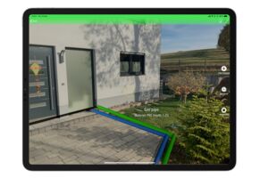
GeoAce is a super-easy to use surveying software for both, surveyors and non-surveyors, who want to accurately collect geospatial data or locate (stakeout) such data on-site. GeoAce turns your smartphone or tablet into a precise, centimeter-accurate surveying system, without the need to use GNSS receivers or total stations.
It uses Visual SLAM positioning and Augmented Reality technology to accurately determine the position of your smartphone/tablet in space and collect 3-dimensional data at the same time directly in the video stream. It doesn’t rely on GNSS positioning, so it can be used also indoors, under tree coverage and even in underground mining. You can connect external GNSS receivers to further increase the versatility of the application.
The results are ready to use drawings in PDF and standard CAD & GIS formats. GeoAce doesn’t require a network connection and all processing and exporting is done on the device.
GeoAce runs on iOS, Android devices and Apple Watch.
Learn more ...
StockAce
StockAce allows you to scan stockpiles, pits or trenches and calculate their volume and mass using Augmented Reality on your iPhone or iPad. No additional hardware or accessories are needed. StockAce doesn’t rely on GNSS positioning and works also indoors and even in underground mining.
Results are instantly exported on-site to PDF, E57 or CSV. All processing is done directly on the device - no network connectivity or additional cloud services are required.
StockAce is designed for iOS devices.

ScanAce
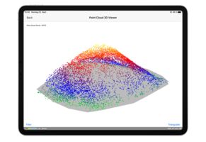
ScanAce is a professional 3D scanning app for surveyors, construction and utility workers, archaeologists, architects, and GIS professionals. It turns your smartphone or tablet into a handheld imaging laser scanner and allows you to precisely capture the reality around you and generate accurate 3D models for planning, documentation or digital twins.
All processing is done on your device, no other services or cloud connections are needed. Results are exported as RGB point cloud in E57 format or as a textured mesh in OBJ.
ScanAce is designed for iOS devices with LiDAR scanner.
ITS View
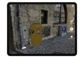
Visualize planned switch boxes, medium voltage stations, high voltage pylons, street lamps, trees and similar features, directly on the spot. Choose 3D-objects from your corporate catalog, make on-the-spot adjustments, take measurements, and directly create realistic photos and videos for your planning and affected property owners.
These media files are geo-tagged and watermarked with position information and can be shared via email. ITS View uses GNSS and Visual Inertial Odometry (VIO) to accurately track the world around it.
ITS View is designed for iOS devices.
Learn more ...